Sailing the southern Pacific Ocean in 1769, two of history’s greatest navigators drafted a remarkable map. One was the British explorer Captain James Cook. The other was Tupaia, an aristocratic high priest from the island of Ra'iātea, who had joined Cook’s expedition in Tahiti. Tupaia was a master navigator who had long voyaged through regions still blank on Cook’s charts.
Tupaia had allied himself with the British, in part to defeat his enemies and bring home guns from England. The British, for their part, were keen to get advice from a local expert, and so Tupaia became Cook’s guide and negotiator.
During the roughly 17 months he traveled with the British, Tupaia impressed the crew as a man of deep learning. He amazed the sailors by correctly pointing in the direction of Tahiti, even after they had sailed around New Zealand and up the east coast of Australia to Indonesia. Cook was particularly intrigued by Tupaia’s claim to know the way to some 130 islands. If Cook could capture the priest’s knowledge on a chart, the British would gain a huge advantage in their Pacific voyages.
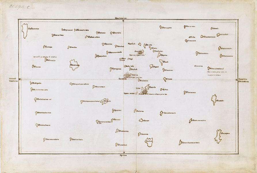
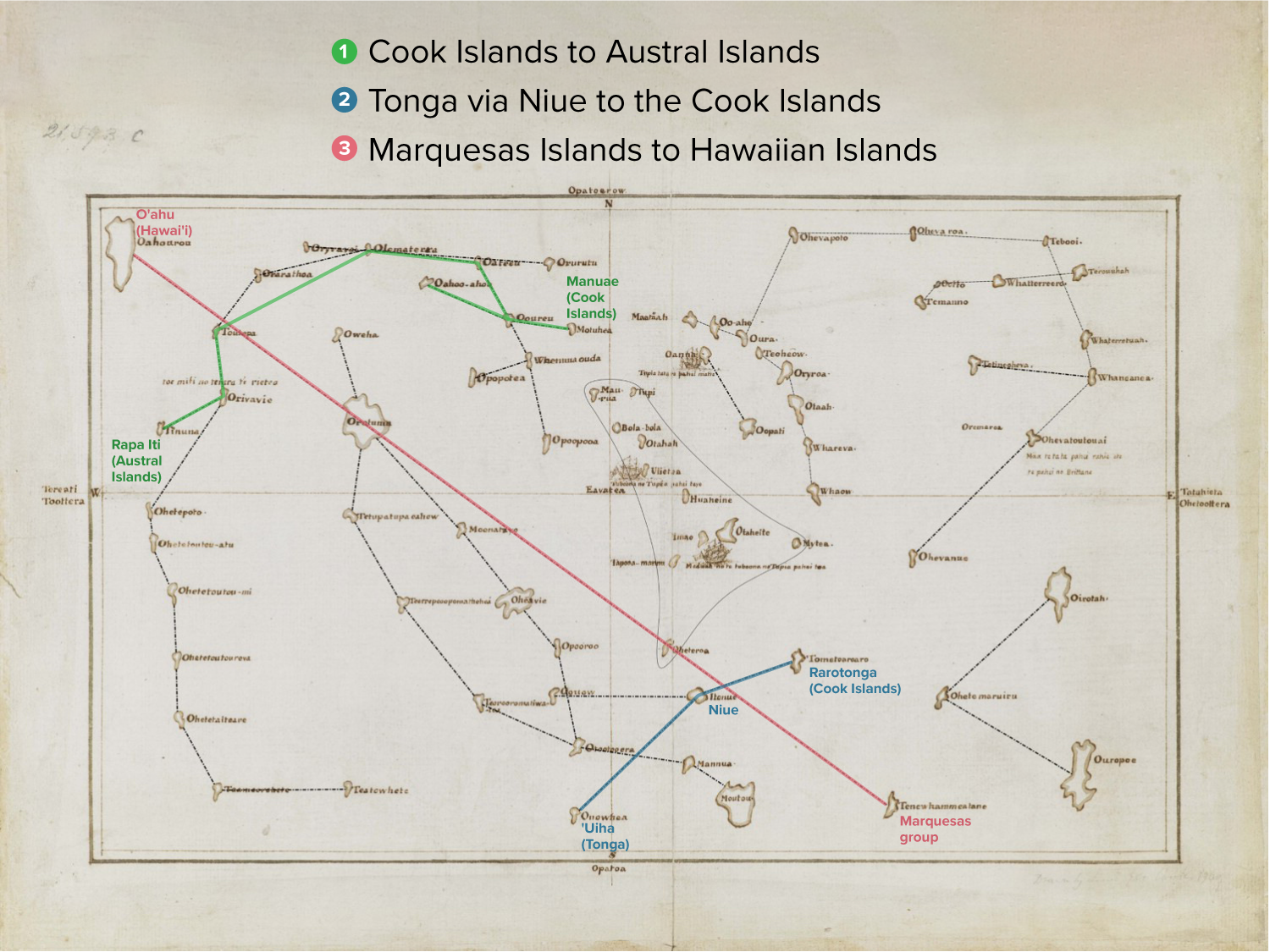
Tupaia drew more than 70 islands on this map and dictated their names to the British. Many of the names echo real place names across the Pacific, but the islands are not drawn in the expected positions according to European mapping conventions. A new interpretation of the map suggests Tupaia did not use the cardinal directions labeled by the British but instead placed north at the map’s center. The original map has been lost, but three copies remain, including this one found in the papers of the Endeavour’s scientific leader, Joseph Banks.
CREDIT: TUPAIA / PUBLIC DOMAIN
At some point during the voyage, the British set up a chart on which Tupaia drew more than 70 islands scattered across the sea and dictated their names. Although the original has been lost, three copies survive in European archives, showing an ocean crowded with islands that don’t match modern charts. Embellished with drawings of ships and enigmatic fragments of Tahitian language, Tupaia’s map has become an object of fascination for generations of scholars and sailors.
Recently, a vigorous debate has centered on an analysis published in 2019 by Lars Eckstein and Anja Schwarz, literary and cultural studies scholars at the University of Potsdam in Germany. They suggest that Tupaia had invented a unique mapping convention that was an ingenious attempt to convey his own geographic knowledge in a form the British would understand. “It’s a translation device that he invented,” says Schwarz.
“You have to forget anything that you know about maps,” says Eckstein. For Cook, a chart was a bird’s-eye view of the curved world stretched onto a two-dimensional plane. Tupaia instead took a canoe’s-eye view, a perspective that shifts depending on where you start from. And while Europeans usually fixed north at the top of the page, Tupaia may have placed north in the center.
The new interpretation overthrows antiquated assumptions about the supposed inferiority of Indigenous knowledge, says David Turnbull, a science studies scholar at Deakin University in Australia. The work of Eckstein and Schwarz is important and illuminating, he says, even though their conclusions may turn out to be hard to prove.
Polynesian wayfinding
Tupaia was heir to a maritime tradition that allowed his ancestors to settle hundreds of islands sprinkled across millions of square miles of ocean, from Hawai‘i to the north, Rapa Nui (Easter Island) to the east and Aotearoa (New Zealand) to the south. Europeans called this region Polynesia.
Polynesian sailors carved boats with stone tools, wove sails from leaves and navigated without instruments. The scale of their achievement is so large that it has sometimes been doubted. In the 1950s, for example, historian Andrew Sharp stimulated a fierce debate by arguing that the last stages of this great migration reflect not deliberate voyaging but one-way trips undertaken by people who were lost or in exile.
“This idea of some sort of random drift is just kind of nonsense,” says Patrick Kirch, an archaeologist at the University of Hawai‘i at Mānoa. Islands were settled by purposeful voyaging enabled by sophisticated wayfinding abilities, Kirch wrote in an article on the settlement of the Pacific in the 2010 Annual Review of Anthropology.
These skills were noticed by Cook, who was one of the first Europeans to chart the Pacific and meet Polynesians. “These people sail in those Seas from Island to Island for several hundred Leagues, the Sun serving them for a Compass by day, and the Moon and Stars by night,” he wrote.
When Cook first met him, Tupaia was chief adviser and lover to Purea, a powerful woman known to the Brits as the “Queen” of Tahiti. Tupaia’s legs were heavily tattooed with the marks of his high status within the 'arioi religious order, whose members included elite navigators. He was known in Tahiti for his intellect. “He was regarded as a bit of a genius,” says Anne Salmond, an anthropologist at the University of Auckland in New Zealand.
He was also a warrior with a grudge. He had been exiled to Tahiti from his home island of Ra'iātea by invaders from Bora Bora, and he still bore the battle scars from being impaled by a spear tipped with a stingray barb. When the British arrived in Tahiti, Tupaia quickly incorporated the visitors into his plans. He tried (in vain, it would turn out) to get Cook to help him drive the Bora Bora warriors out of Ra'iātea.
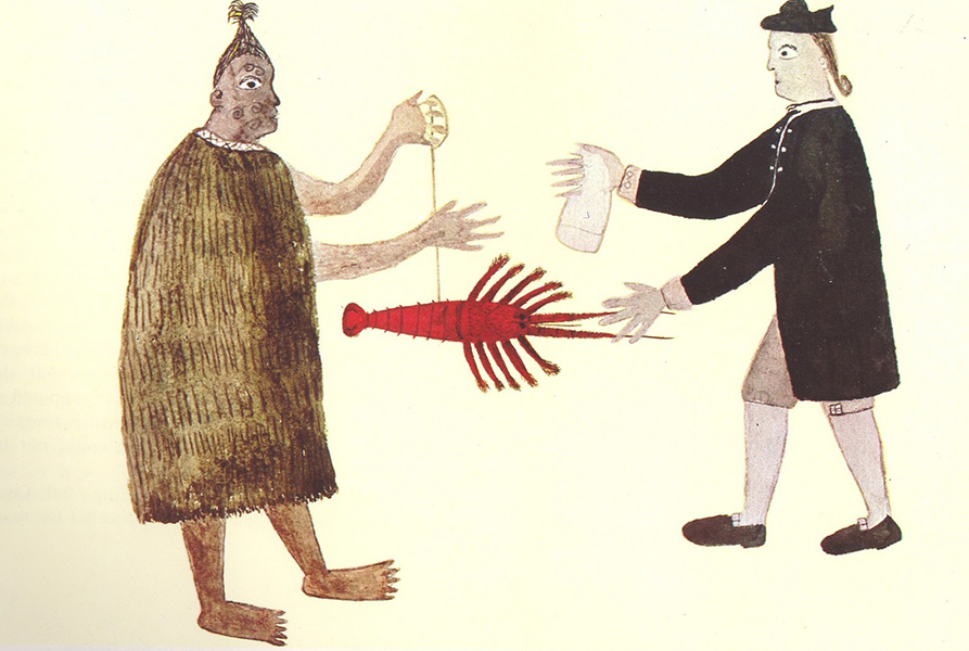
This sketch made by Tupaia in New Zealand shows a Māori man trading a rock lobster with a British man for some cloth. The artist was once thought to be the Endeavour’s chief scientist, but a letter written by Banks in 1812 and discovered only in 1997 revealed that Tupaia had sketched this tense moment of exchange, in which Banks recalled keeping a firm fist on his payment until the moment he had “Livery and Seizin of the article purchased.”
CREDIT: TUPAIA / PUBLIC DOMAIN
Tupaia engaged in many intellectual exchanges with the scientists on the Endeavour (Cook’s ship) and their leader Joseph Banks. Tupaia learned to paint in watercolors alongside the ship’s botanical artists and had many long conversations with Banks and others about history, religion and — most important to the colonizers — geography.
The map is the most famous outcome of these exchanges, surviving only as copies in the archives of Banks and two German scientists who traveled with Cook in later years, Johann Reinhold Forster and his son Georg.
With Ra'iātea in the center, the map depicts Tahiti and a handful of other islands the British knew in roughly the expected positions for a European map, alongside garbled English transcriptions of their Tahitian names. Surrounding these known landmarks are dozens of unknown islands with mysterious labels.
Cook’s crew consulted a copy of the map on a later voyage, but islands did not appear where the map indicated they should. Unable to make sense of the chart, Georg Forster speculated that Tupaia had invented the islands just to appear more intelligent than he really was (despite calling Tupaia an “extraordinary genius” in the same account).
For more than 200 years scholars have tried, and failed, to figure out how the map’s depiction of islands relates to the actual geography of the region. Recent efforts have instead tried to consider the worldview of Indigenous Pacific navigators, who were less concerned with the absolute position of an island than with how to get there.
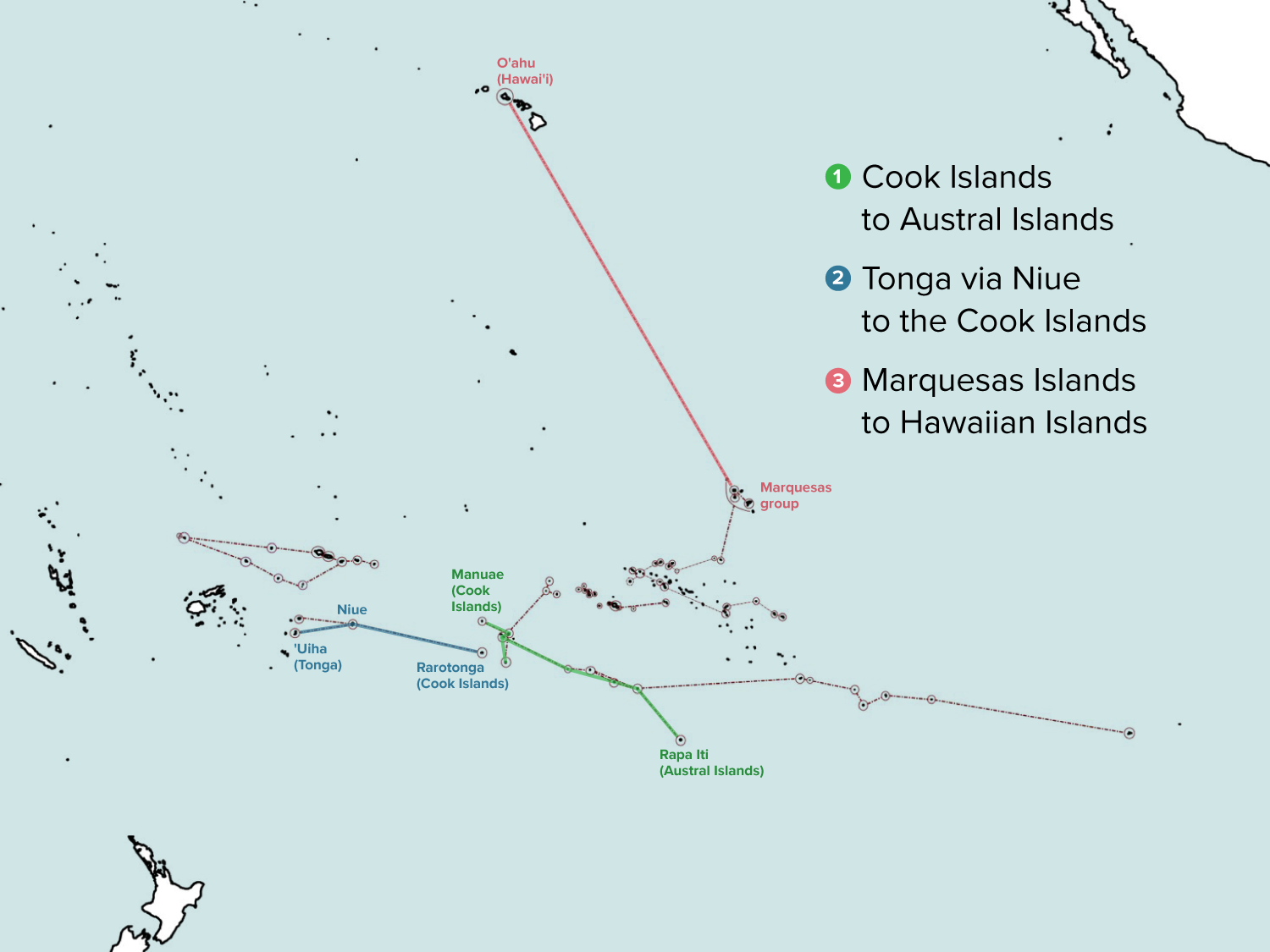
Reaching a distant destination involved island-to-island routes that were memorized in chants and lists, says Schwarz. She and Eckstein reexamined lists of island names that Tupaia had given the Endeavour’s crew and labeled them in the same order on the map. “What emerges is something like a connect-the-dots drawing” that may represent ancient sailing routes, says Eckstein.
The scholars also noticed a largely ignored clue at the center of the map: the word Eavatea.
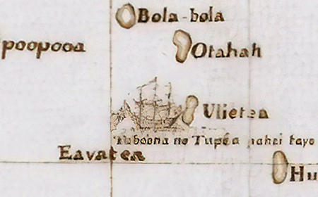
The word “Eavatea” lies at the center of Tupaia’s map, where the cardinal axes cross. Vocabulary lists collected by the British translated the Tahitian word E avatea as “the noon” or the highest position of the sun during the day.
CREDIT: TUPAIA / PUBLIC DOMAIN
Banks translated “E avatea” as “the noon.” Schwarz and Eckstein wondered if Tupaia had intended this annotation as a reference point for his British collaborators. Although the noon position of the sun was not essential for Polynesian navigation, it was crucial for the British.
Each day right before noon, the officers would gather on deck with their instruments to measure the height of the sun above the horizon, marking the exact moment of noon with eight strikes of the Endeavour’s bell. This ritual was part of Cook’s daily procedure for determining the ship’s latitude and calibrating the clock and compass readings.
For navigators like Tupaia, the sun was just one of many positional cues, including the moon and stars, cloud formations, winds, currents and swell patterns. Eckstein and Schwarz suggest that perhaps Tupaia, finding it impossible to condense all this information onto a sheet of paper, devised a shorthand tailored to the British obsession with noon.
They propose that the avatea mark represents north — the usual direction of the noon sun in the Southern Hemisphere. Instead of orienting his map with north at the top, as is the convention on modern maps, Tupaia put it at the center. To reach a particular island in a voyaging path, a navigator starts at an island in the sequence and imagines facing the avatea/north mark. The navigator can now estimate the compass bearing of the next island drawn on the map.
As each destination is reached, the voyager must mentally or physically rotate the map and reorient to avatea. Because the first island in a voyaging path can appear anywhere on the map, avatea bearings can only be read in sequence within a route, not between different routes.
Reinterpreting some of the island names in light of the avatea system, Eckstein and Schwarz have connected the dots into a patchwork of voyaging paths that stretches west to Rotuma in Fiji, north to the Hawaiian archipelago and east to Rapa Nui. By their calculations, the islands fall within an average of 5 percent of their actual geographic bearings along each route.
But not everyone is convinced.
A competing interpretation, advocated by Anne Di Piazza, an anthropologist at Aix-Marseille Université, CNRS, EHESS, CREDO in France, and independent scholar Erik Pearthree, holds that Tupaia’s map is really a mosaic of sailing directions radiating from important departure islands. In this interpretation, each departure island (with its cluster of target islands) has its own orientation, rather than using a single reference point like the avatea mark.
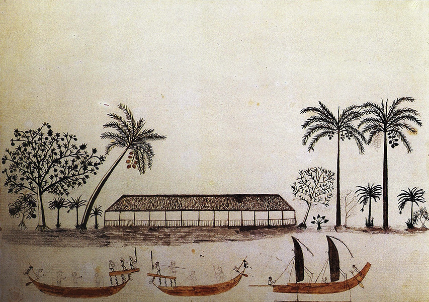
This watercolor painting by Tupaia shows two war canoes with raised fighting platforms and a sailing canoe with an outrigger. On the shore is a Tahitian longhouse and important trees and plants, including breadfruit, banana, coconut, pandanus and taro.
CREDIT: TUPAIA / PUBLIC DOMAIN
In a commentary article, Di Piazza and Pearthree point out that in many cases Eckstein and Schwarz argue for the real-world identity of an island on Tupaia’s map not from independent evidence, such as the island’s name, but from the potentially circular fact that it seems to match an avatea bearing. Di Piazza and Pearthree also note that the vast majority of avatea bearings identified by Eckstein and Schwarz are far enough off the true bearings that a voyager using them would miss their target.
Eckstein responds that the avatea system was not what Tupaia himself would have used to make landfall, but rather his attempt to bridge two geographical worldviews. Tupaia was working from memory on a piece of paper around the size of a laptop screen. “The degree of accuracy, given all that, is stunning,” says Eckstein.
Salmond says that while she admires their meticulous work, she thinks Eckstein and Schwarz overstate the certainty of their conclusions, considering the fragmentary nature of the evidence and the huge gap between the scholars’ worldviews and that of Tupaia. She notes that Tupaia’s ocean was a sacred space where islands were fish pulled from the sea and stars were canoes sailing the sky.
“When you’re piling inference upon inference and drawing deductions — which can get increasingly creaky as you go on — if you’re doing that on the basis of a really different set of assumptions about how the world works, you could go quite far astray,” Salmond says.
Moeata Galenon and Titaua Teipoarii, navigators from Tahiti and Ra'ivavae respectively, also emphasize that there are radical differences in the way academics and Indigenous navigators see the world, adding that collaboration with Indigenous experts is vital for interpreting Tupaia’s map.
Eckstein and Schwarz acknowledge that their perspective is that of Western scholars. Though the pandemic put their plans on hold, they are expanding their collaborations with Tupaia’s cultural heirs and those who still voyage long distances, the people best positioned to make sense of old voyaging paths and Tupaia’s worldview.
Although the details of Tupaia’s knowledge may be lost to history, Pacific people continue to voyage in his wake. To mark the 250-year anniversary of Tupaia’s voyage, in 2019 Galenon and Teipoarii navigated the ship Fa'afaite by the moon and stars from Tahiti to Aotearoa. They are part of a Pacific-wide movement of modern wayfinders who hope to restore inter-island networks disrupted by colonization and to build regional unity around shared challenges like climate change.
Like Tupaia, they exchanged oral traditions with people they met along the voyage. “Our ancestors would navigate to maintain relationships,” says Galenon. “The canoe was the link.”


